Boulder River
Boulder River
March 29, 2007
First descent attempt
NF Stillaguamish 3500 cfs
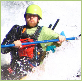
Story and photographs by David Chatham
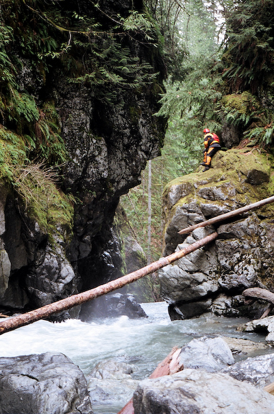
Mike scouting a big horizon line.
The run from below Boulder Falls to Highway 530 is listed on American Whitewater as class III based on a National Park Service study. There is also some commentary on the site that there could be a 50 foot corkscrew waterfall and a 30 foot possibly runnable waterfall on this section. I had first become interested in Boulder river after reading Manning and Spring’s 100 hikes in the Glacier Peak Wilderness area which described the river as being in an old growth forest with waterfalls. A friend of mine and I hiked in last year and scouted the section above Boulder Falls and determined that while very pretty, the section had too much wood to justify the hike in. Boulder Falls was also a class VI waterfall with substantial pin potential, and portaging around the falls would be quite difficult. Before we had gone in to scout, we had visited the forest service office in Darrington but they were not aware of any river information other than what could be seen from the trail.
Mike Novak called me up on the morning of our run and asked about what might be fun to boat that day for his 22nd birthday. We decided that it might be interesting to try a first descent attempt on the section below Boulder Falls based on the above information.
We drove to the trailhead for the Boulder river hike, parked the car and headed downhill to the river. The hike in was actually fairly easy. The start of the run consisted of maybe ½ mile of class II.
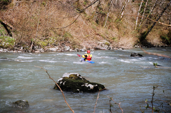
Mike enjoying the easy warm up section.
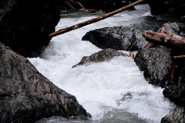
After this, we came to a drop that we both decided to portage as there were no clean lines to avoid a fairly burly looking hole in the center of the drop. We portaged on the left for this one.
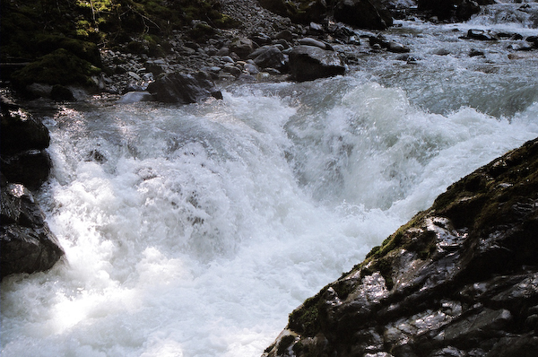
Probable IV+ rapid.
Shortly after this, we came up to another drop which was fairly straightforward, though Mike elected to portage that one on the right because of some pin potential. Not long after this, we came to a longer class III+ to IV- rapid that we scouted on river left. We both had easy runs through this.
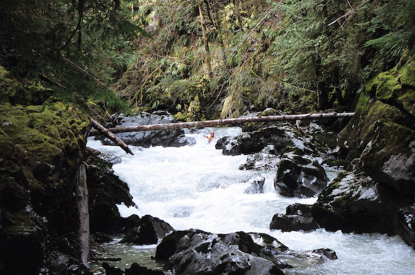
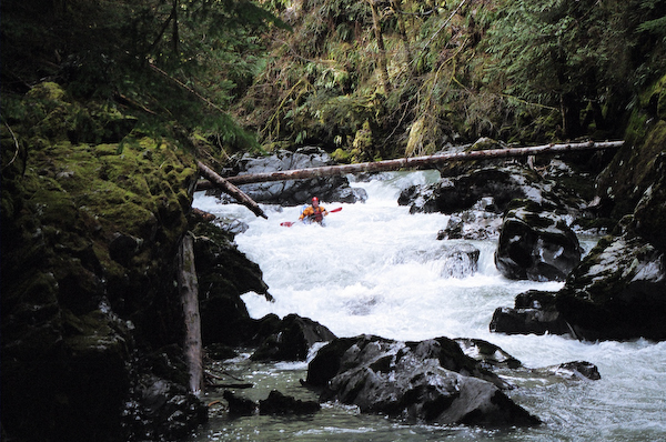
Mike running the most fun rapid of our trip.
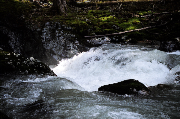
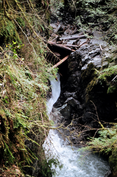
After that, we had to portage around a small logjam on river left. Not too much further down the river, the walls started to canyon up and the river took a bend to the right obstructing the downstream view. We proceeded cautiously, and found that this led into a flat stretch of water. After this, the current picked up a little and led to our first horizon line. I motioned for Mike to eddy out on river right while I scouted the drop from river left. There was a narrow entrance into an approximate 20 foot waterfall which dropped into a pothole on river right about 6-8 feet down, then sprayed out to the left, with a re-circulating eddy on the left at the base of the falls.
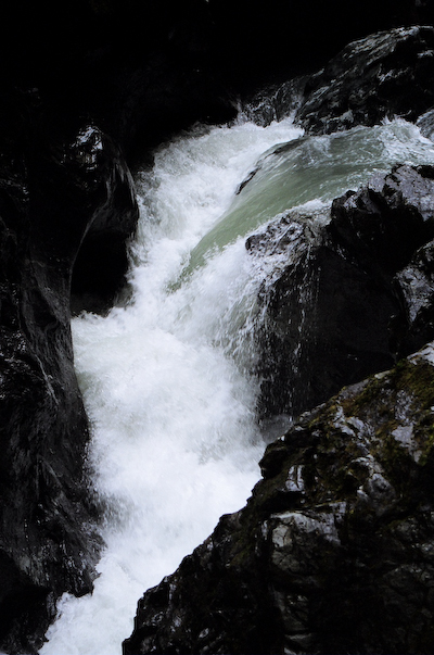
Pothole Falls.
Another 50 feet or so downstream, the river disappeared under a 15 foot high logjam.
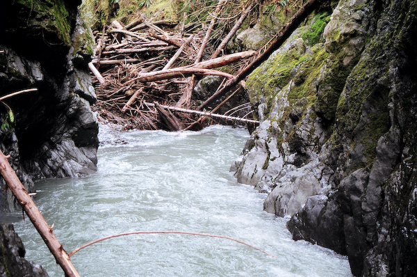
This was shot from roughly the same vantage point as the shot of the
pothole falls.
With high nearly vertical canyon walls, we had no choice but to hike out of the canyon and see if we could re-enter below this section. I had to paddle back upstream and ferry across the river to reach Mike on river right. We made the difficult ascent up a few hundred feet and then hiked along the top of the inner canyon and were able to find a nice viewpoint to see the far side of the logjam. The river dropped approximately 40 feet from directly underneath the logjam , went a short distance, and then plunged over a very nice looking 15 foot or so waterfall.
Looking back upstream at what we had portaged.
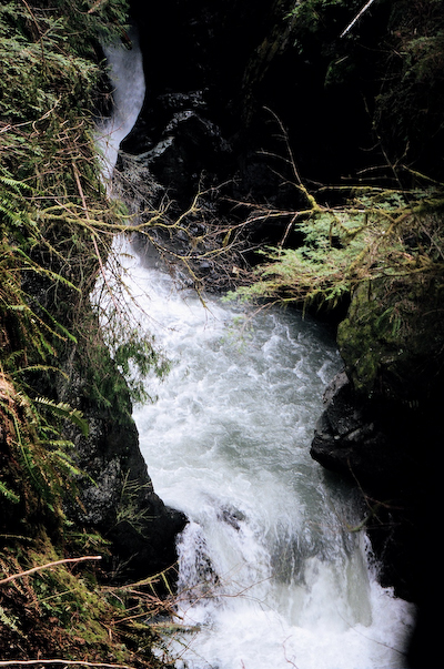
Mike then found a way for us to descend back down to the river. I joked with Mike that hopefully we wouldn’t paddle 50 yards and then have to hike out again. Well, it turned out to be about 75 yards. We eddied out on the right and scouted a class V entry, leading to a 12-15 foot drop, leading to a big horizon line that we could not get very close to. While I was taking photos, Mike worked his way along the river edge and onto a rock outcropping directly above the 12’-15’ drop. Even from there, he had no idea of what lay beyond the horizon line.
Class V entry with the waterfall horizon lines in the background.
Without knowing what we would be heading into, we were forced to make the decision to hike out of the canyon again. We initially tried to hike up from this point, but the walls were too steep to do this safely. We ended up ferrying across the river, hiking back along the left side of the river, and then ferrying back to where we had entered the river after our first portage. By this time, it was getting to be late afternoon and we decided that it would be safest to leave the boats and return for them later. We made it back to the car at dusk.
The next day after work, I hiked in to retrieve my boat and gear. While trying to find the route down to the river, I found myself downstream of the section that we hiked out from. However, the view of the falls was blocked by a very large rock, so I still don’t know what that horizon line led into. After getting back down to the river, I stashed Mike’s boat higher up, and grabbed some of his gear as well as all of my stuff. The hike out of the inner canyon was up a 25 degree or steeper slope with unstable footing and was about 200-250 vertical feet. The hike out was quite arduous, and I got off route and had to again abandon my boat to make it out before dark. A final trip to retrieve boats was uneventful. It was an interesting experience attempting a first descent, though the next time, I think we will probably approach it a little differently. While we made sure we didn’t proceed into anything from which we couldn’t extricate
ourselves if necessary, it certainly would have been easier if we had previously scouted as much of the river as possible form the canyon rim. Also, more people would have made for easier hauling of the boats up the steep slopes.
March 29, 2007
First descent attempt
NF Stillaguamish 3500 cfs
Story and photographs by David Chatham
Mike scouting a big horizon line.
The run from below Boulder Falls to Highway 530 is listed on American Whitewater as class III based on a National Park Service study. There is also some commentary on the site that there could be a 50 foot corkscrew waterfall and a 30 foot possibly runnable waterfall on this section. I had first become interested in Boulder river after reading Manning and Spring’s 100 hikes in the Glacier Peak Wilderness area which described the river as being in an old growth forest with waterfalls. A friend of mine and I hiked in last year and scouted the section above Boulder Falls and determined that while very pretty, the section had too much wood to justify the hike in. Boulder Falls was also a class VI waterfall with substantial pin potential, and portaging around the falls would be quite difficult. Before we had gone in to scout, we had visited the forest service office in Darrington but they were not aware of any river information other than what could be seen from the trail.
Mike Novak called me up on the morning of our run and asked about what might be fun to boat that day for his 22nd birthday. We decided that it might be interesting to try a first descent attempt on the section below Boulder Falls based on the above information.
We drove to the trailhead for the Boulder river hike, parked the car and headed downhill to the river. The hike in was actually fairly easy. The start of the run consisted of maybe ½ mile of class II.
Mike enjoying the easy warm up section.
After this, we came to a drop that we both decided to portage as there were no clean lines to avoid a fairly burly looking hole in the center of the drop. We portaged on the left for this one.
Probable IV+ rapid.
Shortly after this, we came up to another drop which was fairly straightforward, though Mike elected to portage that one on the right because of some pin potential. Not long after this, we came to a longer class III+ to IV- rapid that we scouted on river left. We both had easy runs through this.
Mike running the most fun rapid of our trip.
After that, we had to portage around a small logjam on river left. Not too much further down the river, the walls started to canyon up and the river took a bend to the right obstructing the downstream view. We proceeded cautiously, and found that this led into a flat stretch of water. After this, the current picked up a little and led to our first horizon line. I motioned for Mike to eddy out on river right while I scouted the drop from river left. There was a narrow entrance into an approximate 20 foot waterfall which dropped into a pothole on river right about 6-8 feet down, then sprayed out to the left, with a re-circulating eddy on the left at the base of the falls.
Pothole Falls.
Another 50 feet or so downstream, the river disappeared under a 15 foot high logjam.
This was shot from roughly the same vantage point as the shot of the
pothole falls.
With high nearly vertical canyon walls, we had no choice but to hike out of the canyon and see if we could re-enter below this section. I had to paddle back upstream and ferry across the river to reach Mike on river right. We made the difficult ascent up a few hundred feet and then hiked along the top of the inner canyon and were able to find a nice viewpoint to see the far side of the logjam. The river dropped approximately 40 feet from directly underneath the logjam , went a short distance, and then plunged over a very nice looking 15 foot or so waterfall.
Looking back upstream at what we had portaged.
Mike then found a way for us to descend back down to the river. I joked with Mike that hopefully we wouldn’t paddle 50 yards and then have to hike out again. Well, it turned out to be about 75 yards. We eddied out on the right and scouted a class V entry, leading to a 12-15 foot drop, leading to a big horizon line that we could not get very close to. While I was taking photos, Mike worked his way along the river edge and onto a rock outcropping directly above the 12’-15’ drop. Even from there, he had no idea of what lay beyond the horizon line.
Class V entry with the waterfall horizon lines in the background.
Without knowing what we would be heading into, we were forced to make the decision to hike out of the canyon again. We initially tried to hike up from this point, but the walls were too steep to do this safely. We ended up ferrying across the river, hiking back along the left side of the river, and then ferrying back to where we had entered the river after our first portage. By this time, it was getting to be late afternoon and we decided that it would be safest to leave the boats and return for them later. We made it back to the car at dusk.
The next day after work, I hiked in to retrieve my boat and gear. While trying to find the route down to the river, I found myself downstream of the section that we hiked out from. However, the view of the falls was blocked by a very large rock, so I still don’t know what that horizon line led into. After getting back down to the river, I stashed Mike’s boat higher up, and grabbed some of his gear as well as all of my stuff. The hike out of the inner canyon was up a 25 degree or steeper slope with unstable footing and was about 200-250 vertical feet. The hike out was quite arduous, and I got off route and had to again abandon my boat to make it out before dark. A final trip to retrieve boats was uneventful. It was an interesting experience attempting a first descent, though the next time, I think we will probably approach it a little differently. While we made sure we didn’t proceed into anything from which we couldn’t extricate
ourselves if necessary, it certainly would have been easier if we had previously scouted as much of the river as possible form the canyon rim. Also, more people would have made for easier hauling of the boats up the steep slopes.
posted by slickhorn at 6:52 PM
![]()
![]()
<< Home